


Australian Macadamia [Yield] Disaster?
How badly has Cyclone Alfred affected 2025's macadamia yield prospects for Australian farmers? Time will tell, and assessments of the damage will continue after floodwaters subside.

The Australian macadamia industry is assessing the impact and damage caused by Tropical Cyclone “Alfred” on key growing regions.
As such, the 2025 crop forecast has of course been delayed. Damaging winds, heavy rain, and flooding have heavily affected orchards and notably, this years yield.
The The Australian Macadamia Society (AMS) had previously projected a 5% year-on-year increase on yield, but this will now be reviewed as farmers focus on safety, clean-up, and damage assessment. An updated forecast is expected within ± two weeks (late March to early April, 2025).
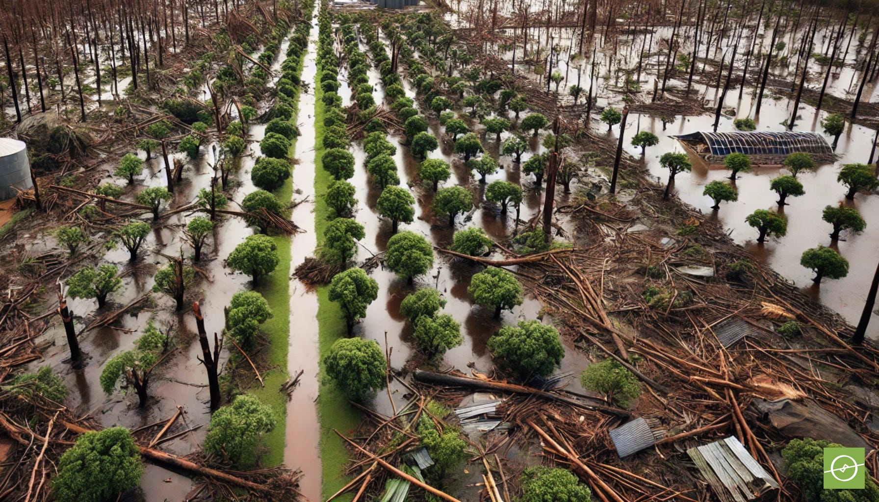
Macadamia farms can suffer severe damage from cyclone-induced flooding due to strong winds, excessive rainfall, and prolonged water-logging.
Here’s how cyclones impact macadamia orchards:
1. Wind Damage
Strong winds can uproot trees, break branches, and cause premature nut drop.
Younger and larger trees alike are vulnerable. Although a big part of modern agriculture, irrigated orchards can have trees with shallower root systems - as water is readily available near the surface of the soil - and these trees are easily uprooted in strong gusts.
2. Flooding & Water-logging
Macadamia trees are highly sensitive to water-logging. Standing water for more than 48 hours can lead to root rot and rapid tree decline or death.
Excess moisture can cause soil erosion, washing away topsoil vital nutrients.
3. Disease & Pests
Phytophthora root rot can develop due to prolonged wet conditions.
Fungal infections like blossom blight increase after high humidity and rain.
Flooding can also lead to an increase in pests, such as borers and nut beetles.
4. Crop Loss
If nuts are at a critical stage of development, they may drop prematurely and be lost.
Even nuts that stay on trees might be affected by mould or fungus due to excess moisture and high humidity levels.
Macadamia Producing Regions Affected by Cyclones
Australia
Tropical Cyclone Alfred (2025): In March 2025, ex-Tropical Cyclone Alfred brought damaging winds, heavy rainfall, and flooding to key macadamia-growing regions. The Australian Macadamia Society (AMS) reported that it's too early to quantify the full impact, but the initial crop forecast of a 5% year-on-year increase to 56,890 tonnes in-shell at 3.5% moisture is now under review.
Aussie Flooding (2022): Severe weather and flooding in New South Wales and South East Queensland affected the 2022 macadamia crop. Early predictions estimated up to a 10% loss in the affected regions, with concerns about orchard cleanup delaying harvests.
Zimbabwe
Cyclone Anna (2022): The Chipinge growing region in eastern Zimbabwe suffered heavy losses after mature macadamia trees were uprooted by Cyclone Anna. This region had previously seen an expansion in macadamia cultivation, with many smallholders entering the sector.
Malawi
Cyclone Freddy (2023): Macadamia farmers in Malawi faced significant challenges due to Cyclone Freddy in March 2023, which destroyed crops and scattered macadamia fruits from trees. This event highlighted the vulnerability of macadamia cultivation to extreme weather events in the region.
These events underscore the susceptibility of macadamia-producing regions to cyclones and the importance of implementing strategies to mitigate such risks.
Recovery & Prevention?
Drainage systems are critical to prevent prolonged water-logging and divert water away from trees and/or help to drain low lying areas.
Windbreaks (like rows of tall trees) help protect orchards from strong winds.
Proper orchard management can reduce disease risks after flooding, but taking measures to move standing water, and improve drainage.
If trees survive, post-flood nutrition management (ie. calcium, potassium, and phosphorus applications) can help them recover.
Drone surveys and Mapping
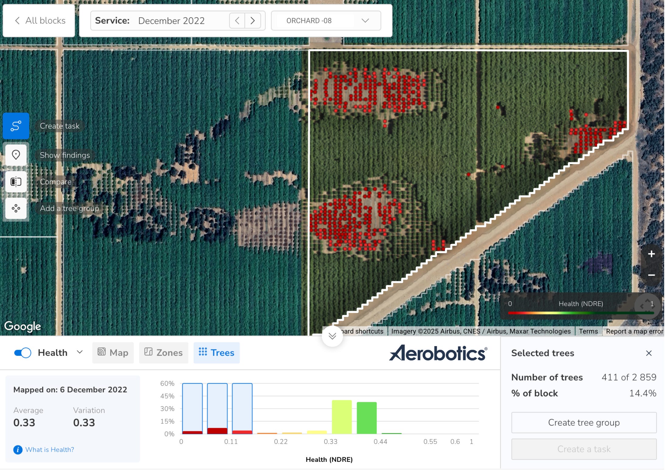
UAVs play a crucial role in assessing damage to macadamia orchards after severe weather events. High-resolution aerial imagery allows farmers and agronomists to quickly identify affected areas, including uprooted trees, broken branches, and flood-damaged zones.
Unlike ground-based assessments, which can be slow and limited by accessibility, drones provide a comprehensive view of the entire orchard, even in areas that are difficult to reach due to flooding or debris.
By using multispectral and thermal imaging, drones help detect less obvious damage, such as water stress in trees, early signs of disease, or soil erosion caused by excessive rainfall.
This data enables precise decision-making for orchard recovery, such as prioritising drainage improvements, replanting strategies, and targeted fertilisation to support tree health.
Additionally, geotagged imagery allows for accurate documentation of losses, which is useful for insurance claims and disaster relief applications.
Metrics that help quantify damage:
Low Health: Established trees, now with NDRE between 0.15 and 0.25
For younger trees (< 2-3yrs old) look at the same values, but with NDVI, which is best for monitoring vegetation of smaller plants, at per-plant level.Dead Trees: Trees with no recognisable green vegetation (or NDVI less than 0.15) - most likely due to high winds, or induced leaf drop, due to free-standing water for prolonged periods.
Sometimes these trees recover, but in most cases they are damaged severely either physically, or at the root zone due to flooding and standing water, and will be recorded as an asset loss.
Replacing these trees with healthy one’s after damage assessments and site rehabilitations, may be the best option in terms of a quick orchard turnaround, rather than a prolonged tree rejuvenation process. Of course, this is different in each situation and something to consider after severe weather events like these.Missing Trees: Trees that were once there, that no longer exist or their canopies are missing. In essence a measure of the number of gaps in the orchard that denote a “missing tree”.
All the figures above help with a recon of tree inventory after the sever weather event, compared to the known orchard status before the event.

Beyond orchard recovery, drone mapping is essential for optimising resource allocation and infrastructure repairs.
It helps authorities and farm managers identify damaged roads, irrigation systems, and processing facilities, ensuring that emergency repairs and aid are directed where they are needed most.
By creating up-to-date maps, decision-makers can develop more effective long-term resilience strategies, such as improved windbreak placement, better water management, and enhanced soil conservation practices to mitigate any future cyclone impacts.
Drones are fast becoming a staple in the arsenal for farmers looking to rise again after the toughest of challenges. It’s all part-and-parcel of the mission for greater farming resilience in the face of increased adversities and uncertainties.
You may also like:
When Yield Predictions Crack: The 5 Worst Forecasting Failures (Nut Industry)

Nut yields are notoriously difficult to predict, as yields are highly variable across regions, orchards, and cultivars. Many of the causes of this variability are still unknown. But what is well know, is that there are always risks to yield in any given season.
Drones: Unlocking Macadamia Farming's Future

First off, I’m referring to “drones” as being Unmanned Aerial Vehicles (UAVs), remotely controlled, or autonomously operated. Typically used for tasks including aerial photography, proactive or reactive surveying (more on that later), security, and surveillance.
Drones, Plant health, Input Costs, Water Use, and Variable Rate Applications

Large-scale agriculture is saturated with the pursuit of higher yields and bigger profits. Often at the expense of the environment and notions of [real] longterm sustainability.